


Territorial analytical data belong to spatial planning documents; they determine and evaluate the condition and development of the territory. They focus on discussing given conditions in the region that could benefit the public interests, changes in the territory, identify and evaluate sustainable development and identify problems to be addressed in spatial planning documentation. It serves mainly as a basis for the acquisition of territorial development policy as well as for the collection of spatial planning documentation, its changes and updates.
ÚAP Pk contain:
a) documents for the analysis of sustainable development of the territory (1st part of the documentation),
b) analysis of sustainable territorial development,
– identification and evaluation of positives and negatives in the territory (Part 2),
– evaluation of territorial conditions and potentials of individual pillars of sustainable territorial development (Part 3),
– identification of problems to be solved (Part 4).
The text part of ÚAP Pk contains the following parts:
Part 1 of the documentation contains documents for the analysis of sustainable development of the territory divided into thirteen thematic parts according to § 4, paragraph 2 a) of the Decree, brief commentary on phenomena according to Annex No. 1 part B to the Decree and comments on drawings of values, land use limits and plans to make changes in the territory.
Part 2 of the documentation contains findings and evaluations of positives and negatives in the area in a specified thematic division.
Part 3 of the documentation contains an evaluation of the territorial conditions and potentials of the individual pillars of sustainable development – that is for a favorable environment, economic development and cohesion of the community, including their interrelationships and development trends.
Part 4 of the documentation contains the identification of problems to be solved in the Principles of Territorial Development of the Pardubice Region (ZÚR Pk), including requirements for elimination or reduction of urban, transport and hygiene defects, mutual conflicts of plans to make changes in the territory and conflicts of these plans with land use limits and weaknesses, threats and risks related to the imbalance of territorial conditions of sustainable development of the territory.
The graphic part of ÚAP Pk contains:
- drawing of territory values in scale 1: 100 000,
- drawing of land use limits at a scale of 1 : 100,000,
- drawing of plans for changes in the territory at a scale of 1: 100,000,
- drawing of problems to be solved in territorial planning documentation (problem drawing) in scale 1: 100 000.
Territorial analytical data Pk – text part
Drawing of plans to make changes in the territory
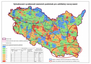
Evaluation of the balance of territorial conditions for sustainable territorial development
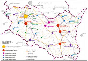
Structure of the Pardubice region – category of centers